Wednesday, April 16, 2014

DOQQ


A digital orthographic quarter quad combines the characteristics of an aerial photograph and those of a traditional map. Most go through a process of georeferencing and orthorectification. Above is one of Delaware.
 http://www.wr.udel.edu/cb/characteristicsandsamplegismaps.html

Index Value Plot

Plot of monthly PDO values.

In an index value plot, we have index values being compared as opposed to absolute or total values.  In our example graph we are basically measuring seismic activity in a region of the Pacific Ocean.  With the years on the bottom, we see that all years with a positive index, one that is above zero, we have more than average activity and that every year below zero we see less than average activity.  The reason that the average is zero on this graph is because we have standardized the variable.  Thus, our graph essentially measures how far above or below average a certain year was as far as quantity of seismic activity goes.

http://www.jisao.washington.edu/data/pdo/

PLSS map


The PLSS maps were the first type of cadastral map ever created in the United States or even any modern country. It has been readily updated over the past couple hundred years or so.

http://en.wikipedia.org/wiki/Public_Land_Survey_System

Parallel Coordinate Graph

para_example_1.png
A parallel coordinate graph places data on a coordinate grid as a line or profile. The lines overlap and a
reader is able to make inferences about the relationship of the data.

http://stn.spotfire.com/spotfire_client_help/para/para_what_is_a_parallel_coordinate_plot.htm

Nominal Area Choropleth Map


These types of maps show how areas compare to each other using nominal data displayed on the map. The map above shows data on the distribution of college basketball players.

http://go.owu.edu/~jbkrygie/krygier_html/geog_353/geog_353_lo/geog_353_lo07.html

Box Plot


 A box plot, also called a box and whisker plot due to the extensions away from the box referred to as the whiskers, shows five points of data: the median, the first and third quartiles, and the minimum and maximum values.  On our box plot, we are measuring temperature and can see that we have a median temperature of 36 degrees, which is the line, usually closer to the center of the box.  The actual box represents the middle 50 percent of data, saying that 50 percent of the temperatures were found between 23 and 44 degrees.  The extensions away show the relative max and min, 55 and 13 degrees respectively.

http://weatherstories.ssec.wisc.edu/stories/armistice_day/climate.html

Unstandardized Choropleth Map


Choropleth maps contain some type of data displayed over and areal average. The data in unstandardized versions of these maps contain unorganized and unranked data. Above is unemployment data in January in the U.S.

http://www.creativeclass.com/_v3/creative_class/2009/03/12/state-unemployment-map/

Windrose

wind rose plot

A wind rose is a circular graph which measures the direction, intensity, and frequency of winds in a particular area.  The example graph is from Klamath Falls, Oregon and shows wind data from the start of 2006 through the end of 2010.  We can see that the strongest and most frequent winds blew North North West, and that the next most frequent winds were low speed winds headed South.  The wind rose is a very easy map to read as direction and length represent direction and frequency, with a color indication of wind speed, or intensity.

http://nj.usgs.gov/grapher/tutorial/examples.html

Isopleth

Isobars & Pressures
An isopleth is just another name for a contour map. Any map which has lines that connect geographic points with the same data can be considered to be one. Many of the other maps on this blog fall under this category including isotachs and isohyets.  This contour map contains isobars, which represent areas with the same air pressure.

http://www.ametsoc.org/amsedu/dstreme/extras/usr_guide/sfc_pres.html

Similarity Matrix

CXB strain Matrix
The similarity matrix is a type o map used in data gathering and comparison. The data of the different variables in the matrix show the similarities between them. These are useful for people who are attempting to gather trends out of a set of data. The data above are comparing different genotypes.

http://www.nervenet.org/papers/bxn.html

Correlation Matrix

Correlation Matrix (Level One Five Factors)

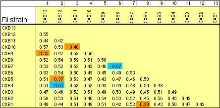
A correlation matrix is exactly what it sounds like.  It is a matrix, which is a group of arranged numbers, that shows correlation, which is expected variable dependence on other variables.  Each number in the matrix represents how much each specific variable is correlated with another specific variable.  The closer to one, the more positively correlated.  The closer to negative one, the more negatively correlated.  The closer to zero, the more uncorrelated are the two variables.  In this matrix we see the correlation intelligence, fun, organization, candidness, and sincerity have on one another.

http://jiad.org/article86.html

Cadastral Map


A cadastral map is one that is most utilized by persons involved in the real estate industry. Often times they are maps of neighborhoods, possibly outlining individual plots of land or even displaying the market value for each plot. Things like roads and wells can often be found on these types of maps as well.

http://www.spaceage.co.in/cadastral-surveys.php

Statistical Map

statistical abstract Statistical Abstract Saved by ProQuest and Bernan Press
Many different sorts of maps fall under the umbrella of statistical maps. Dot distribution maps, choropleth maps and proportional circle maps are some main examples. In the map above percent change in population for each individual state is shown. The exact percent is shown for each state along with different shades of green which represent different ranges.

http://reviews.libraryjournal.com/2012/03/reference/statistical-abstract-saved-by-proquest-and-bernan-press/

Bilateral Graph

Canada-Ireland-graph-1

A bilateral graph is a type of bar graph that shows two (or more) sets of data.  The placement and coloring of the lines makes for easy comparison between the data.  In this graph, we have Canadian to Irish exports and imports.  We can see that in 2010 commerce between the two groups declined, as both exports and imports were lower than years previous.  The bilateral graph makes it easy for us to compare exports vs exports from other years, imports vs imports from other years, and exports vs imports from the same year.

http://www.icccmtl.com/about/canada-ireland-trade/

Isopach


An isopach is yet another style of contour map. The isolines on these maps represent the rock or sediment thickness of a geographic feature. The map above features a volcano with a layer of ash after an eruption. The contour lines actually measure the amount of ash (or sediment) on each section of the volcano.

http://www.volcano.si.edu/volcano.cfm?vn=357100&bgvn=1&rnum=region15&snum=andes_c&wvol=lonquim&tab=1

Proportional Circle Map


This type of graph is a proportional circle map.  The map shows circles of different sizes against a geography, in this case of the United States.  The size of each circle is proportional to the data being measured, in this case aggravated assault arrests.  The smaller circles over states like Montana show that a small proportion of total aggravated assault arrests occurred in Montana, while the large circle over California says that a large proportion of the total aggravated assault arrests occurred in the state of California.

  http://personal.frostburg.edu/jaelder0/symbolizarion%20map%202.jpg

Star Plot


The type of map shown above is one of the most useful when attempting to explain concepts. Each piece of data is spread apart from each other such that, the closer each individual piece of data is to each other the more closely related the data points are. It can show multiple variables in one chart and the distance between each other on the chart is often conveyed using colored lines.

http://en.wikipedia.org/wiki/Radar_chart

Accumulative Line Graph

A example of a cumulative flow diagram
A line graph is a type of map that is known to show the change in data or a variable over the course of time. An accumulative line graph does the same thing, but adds up all the stats and data as a whole and displays it on the chart. It makes it easier to gather inferences and trends as opposed to looking at the data from only one perspective (over time).

http://www.robertperrine.biz/Perrine_PMO/Perrine_PMO_Notes.html

Standardized Choropleth

USA-population-density-per-square-mile
These type of maps contain data, usually relating to population, standardized over a general area of distance, such as a square mile. A popular subject of these types of maps is population per square mile as shown in the example above. The darkest colors represent the more dense areas, and the lighter areas signify a less packed area.

http://modernsurvivalblog.com/retreat-living/survival-retreat-population-density/

Bivariate Choropleth Map


To be classified as Bivariate Choropleth map two main characteristics must be fulfilled. First of off there must be two obviously present variables shown and the other is that these variables are used along with areal data. In the map above it shows two distinct things, the ratio of Olympic athletes per capita along with the fact, if they are winter or summer competitors.

http://www.directionsmag.com/images/articles/sportsillustrated/Olympic_Athletes.jpg

Tuesday, April 15, 2014

Isotachs

250 mb analysis at 1200 UTC 26 June 2006
An isotach is yet another type of contour map. The defining characteristic of these though is that its contour lines connect areas of the same wind speed. These maps prove especially useful in navigating routes for airplanes along with forecasting weather patterns in meteorology. The map above is from the National Weather Service and displays wind patterns across the continental US.

http://www.weather.gov/gsp/26June06Flooding

Population Profile

2010 Census: State Population Profile Maps
A population profile breaks a country or region's population into profiles based on their age. The profile can include gender as well. This kind of chart is useful for observers who wish to gather data and target specific demographics in fields such as advertising and employment assistance. In the example above, Washington D.C.'s population profile is shown. Young adults clearly dominate the profile and there seem to be a significant difference between the male and female population.

http://www.census.gov/2010census/

Isohyets


An isohyet is another style of contour map. Instead of relief, which normal contour maps represent, isohyets are lines that represent rainfall statictics.  The map above is the 40 year isohyet average in the United States from 1973. The lines connect points that have the same amount of rainfall as each other.

http://web.ead.anl.gov/resrad/datacoll/water.htm


Stem and Leaf Plot


When one wants to group numerical data by tens, but visibly see each individual number, would choose to display data in a stem and leaf plot. Often used for straightforward data such as test scores, stem and leaf plots have the tens digit (for example: 5 in 56) of a number on the left side of a table separated by a line with the ones digit (6 in 56) all of the individual scores in that range across from it on the right hand side. In the graph above a regular class's test scores are depicted. 56 is the low score and 97 is the highest.

http://mrnussbaum.com/mathdrills/graphing/stemandleaf2.htm

Climograph

Climate Miami - Florida
Climographs show monthly averages of weather in a location. Included in these are average  low and high temperature and average rainfall. They prove useful to people who are looking to travel or vacation as one can look at past data and make informed decisions what time of year to go there. In the graph above average rainfall is shown in the blue bars and temperature averages are represented by the dark blue and red lines that are horizontally imposed over bars. This is the city Miami's climograph.

http://weatherclimate-akess.blogspot.com/

Thematic Maps

Percent unemployment in May 2009 map
Thematic maps are maybe the most used maps when it comes to data. They encompass a vast variety of maps including but not limited to dot distribution maps, chloropleth maps, and isoline maps. The unifying characteristic of these maps is that they all convey data on a topic superimposed onto an original basemap. For example the map above, has unemployment data classified into different groupings over a base map of the counties of Missouri.

http://www.oseda.missouri.edu/articles_chron.shtml

Infrared Aerial Photo


Above is an aerial photo of the San Joaquin River Valley Delta near Sacramento, California. Developed using the infrared spectrum, a reader of the map is able to benefit greatly with the visibly distinct separation of topographic features. Because the different shades of red make each feature of the map distinct, it further amplifies the ability to reference points as if you were in a plane above the region.

http://aerialarchives.photoshelter.com/gallery/Infrared-Aerial-Photography/G0000FeWbK1_GNLQ/

Mental Map


A mental map is one in which the map creator uses personal reference points from past experiences to remember specific details and qualities of the area being mapped. The example above is a simple map from a little child and displays what details he/she recalls as important. The street names and elementary school are the obvious ones, but the palm trees on the corner and many houses on the grass are prominent features as well. There might have been other features left off, like driveways for the houses, but that is part of the process of mental mapping and deciding what is vital to the map.

http://moodle.oakland.k12.mi.us/os/mod/page/view.php?id=31767

Scatterplot


Scatter plots are graphs that make it easy to compare the correlation between two variables. The x axis can have a range of variable data or represent change over time. In the example above SAT score is compared to graduation rate. The scatter plot makes relating this data incredibly easy. One would reasonably presume that higher SAT scores would yield a higher graduation case, but the scatter plot clearly conveys this isn't quite as straightforward as one would think. That is the power of this type of graph, allowing the interpreter to easily relate the relevance and correlation of the two variables in question.

http://jwilson.coe.uga.edu/EMT668/EMAT6680.2002/Curro/EMAT%206700/Chapter%206/Section3.html

Hypsometric Map


Any surface map showing relief and some type of three dimensional data can fall under the category of a Hypsometric map. Coloring, shaping, contour line, and raised relief are all ways this said third dimension can be expressed on these types of maps. The example above is a map showing relief in California. Changes in elevation are represented by different shadings of color.

http://www.geomart.com/products/raisedrelief/states.htm

Bathymetric Map

first realistic bathymetric map of any oceanic basin in the Gulf of Mexico

Bathymetric maps are a type of contour map that use isolines to portray sea floor elevation. Similarly to how the spacing contour lines represents the grade of a slope on a mountain on a topographic map, the same principal is applied to ocean depth in the opposite direction. Above is one of the first bathymetric maps to even somewhat accurately portray any ocean basin. The basin in the map displayed is the Gulf of Mexico between the years 1873- 1875.

http://celebrating200years.noaa.gov/events/survey/gulf_of_mexico.html

Histogram

histogram of heights of people

A vital component of maps is their ability to organize data. No where is it more evident than in the use of histograms. As shown in the example above, data is grouped into easily deciphered categories placed into different bars based on height. The independent variable which is normally on the x axis is height, and the dependent variable, frequency in this case, is usually found on the y axis.

http://www.analyzemath.com/statistics/histogram.html

Unstandardized Choropleth Map

Small African Languages Map

An unstandardized choropleth map is one in which data has been split up into distinct groups but without the aerial averages. Colors are used to represent where different African languages are spoken as opposed to using ratios or numbers to convey the differences in data.

http://www.nationsonline.org/oneworld/african_languages.htm

Digital Raster Graphics


Above is a DRG display of Washington, D.C. All DRGs are scanned images of the USGS topographic maps, and are often used in combination with other types of digital map making. The data gained from DRGs can even be used to revise and tweak the info of other maps that use digital data, most commonly DLGs

.http://gislab.lanl.gov/faq.html

Digital Line Graph


The above is a DLG of Yellowstone park displayin information regarding topography as well hydrology and roads. What classifies this as a DLG is the fact that it was created through the use of digital vector data. Map data about features are stored as lines, points and polygons and then applied to the vectors. DLGs are very versatile and can display a large assortment of information.

http://web.wt.net/daba/dlg/default.html

Digital Elevation Model


Above is a DEM for Red Rocks Amphitheater in Morrison, CO. The model is done in Raster format, meaning the related cartographic information is recorded, stored and processed in a pixel. The information generated from this process (relief) here is represented by the change in color on the map. The standard USGS raw DEM has a resolution of 30 x 30.

http://en.wikipedia.org/wiki/Digital_elevation_model

LIDAR

gsa_lidar_24x16_web

LIDAR is laser- pulse based imagery that when combined with a GIS mapping program create stunningly detailed portrayals of highly specialized surface phenomena. This particular picture is a digital elevation map and covers a 675 sq KM region in Rex, NC. Topographic elevation is represented by the shade of colors on the map, the lightest in the bottom right corner represents 16 m and the darkest, 76 m in the upper left.

http://cintos.org/LiDAR_images/

Isobars

figure4

Isobars are a type of contour map (maps that use isolines) that is used to show changes in air pressure. Measured in millibars, the further away each line is from the other, the greater the change in air pressure. Pictured above is a cold front over Australia where the high pressure area is denoted with a H and low pressure with a L.

http://hsc.csu.edu.au/primary_ind/prim_ind_240/compulsory/AHCWRK201A/3264/reading_weather_maps.htm


Topographic Map

Large Scale Mount Marcy Topographic Map

A topographic map is a contour map that displays terrestrial elevation on a two- dimensional map. Above is a topographical map of Mount Marcy and its surrounding areas in New York State. The lines on the map represent the changes in elevation and shapes of the physical features like cliffs and ridges in the region. The closer together the steeper a feature is. Mount Marcy is the highest point on the map.

http://www.adirondacknorthway.net/mappages/mount_marcytopo.php

Doppler Radar

NOAA National Weather Service Melbourne, Fla., Doppler radar image of Hurricane Frances taken at 11:34 p.m. EDT on Sept. 4, 2004, as the western edge of the powerful storm’s center moves inland on the Florida east coast.

Above is a Doppler radar image from the National Weather Service from Hurricane Frances in 2004. The direction and speed of water droplets suspended in the air are recorded through the use of microwaves by the Doppler system. Computers then take the data and turn it into visible images of weather patterns over different sections of the globe.

http://www.noaanews.noaa.gov/stories2004/s2311.htm

Propaganda Maps

Nazi Prop surrounded538

Propaganda as defined by the American Heritage Dictionary is
  "Official government communications to the public that are designed to influence opinion. The information may be true or false, but it is always carefully selected for its political effect."

When maps are used for this purpose they fall into the category of propaganda maps. This map was used by the Nazi Party in the 1930s to make it seem as if the countries surrounding Germany were threatening it, influencing the population to be further in favor of war. Upon first glance it certainly looks as if Germany is unfavorably surrounded.

http://longstreet.typepad.com/thesciencebookstore/2010/10/nazi-propaganda-germany-surrounded-1933.html

Dot Distribution Maps


The map above shows the distribution of public libraries throughout the U.S. Each dot is representative of a single library in that location. As opposed to proportional circles, the dots allow for a visual aid to represent density of the variable. One can easily see where the highest concentration of libraries are right away. These characteristics classify the image above as a dot distribution map.

http://gothos.info/2013/03/the-geography-of-us-public-libraries/

Black and White Aerial Photo

Docklands black and white cb32952bw.jpg

Above is a black and white aerial photograph of the Docklands in London. Here the visible spectrum light is captured from a plane or helicopter using a standard camera. A picture is considered to be a map because it holds many of the same basic elements. Scale, orientation, and symbolism can all be derived from the picture above the same or better than one could from what one thinks of a traditional map.

http://www.webbaviation.co.uk/gallery/v/greater_london/Docklands/Docklands_cb32952bw.jpg.html

Univariate Choropleth Map


A univariate choropleth map is one that only shows one variable combined with some type of areal data. In this map the result of the 2012 House of Representatives election is shown in each state. The only thing that is shown is if the Republicans (in red) or the Democrats (in Blue) won the majority. These maps are generally the simplest kind to read and interpret.

http://www.electionresources.org/us/maps/representatives.php?election=2012

Classed Choropleth Map


U.S. Census Bureau Population Change Estimates from 2000-09.

Above is the estimated population change for U.S. counties from the years 2000-2009. Each of the five colors on the map represent a range of percentage change in population and each county has one of these colors filled in on the map. Because the map portrays areal data (the counties) and the data is split up into groups, it can be classified as a classed choropleth map. Most of these maps usually contain four to seven groups.